Located halfway between the Equator and the North Pole, Romania is the 12th largest country in Europe.
Romania's terrain is almost evenly divided between mountains, hills and plains.
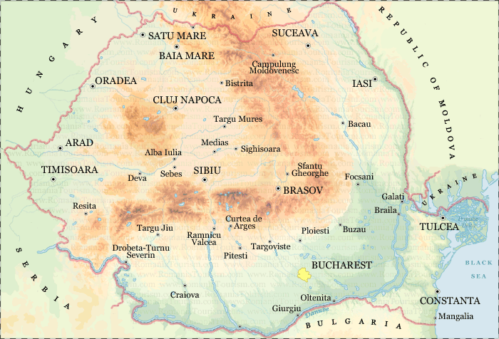
The Carpathian Mountains
Although not as high as the Alps, the Carpathian Mountains extend over 600 miles in Romania, in the shape of an arch. They are divided into three major ranges: the Eastern (Oriental) Carpathians, the Southern Carpathians (also known as the Transylvanian Alps), and the Western Carpathians. Each of these ranges feature a variety of landscapes, due to the different types of terrain (glacial, karstic, structural, and volcanic).
Romania's mountains are a great destination for numerous outdoor activities including: climbing, hiking, biking and river-rafting. Some of the most popular ski resorts are Poiana Brasov, Sinaia, Predeal, Vatra Dornei, Lake Balea and Paltinis.
The Danube Delta
Danube River ends its journey of almost 1864 miles through Europe in south-eastern Romania.
Here the Danube divides into 3 frayed branches (Chilia, Sulina, Sfântu Gheorghe) forming the Danube Delta.
It is the newest land in the country, with beaches expanding almost 65 feet into the sea every year.
Overall, the delta is a triangular swampy area of marshes, floating reed islands and sandbanks.
It is a UNESCO Biosphere Reservation as well as a protected wetland and natural habitat for rare species of plants and animals.
More information on the Danube Delta
The Black Sea
The Romanian Black Sea Coast stretches a little over 150 miles.
The Black Sea is a continental sea, with a low tide and salinity and water temperatures of 77 - 79˚F in the summertime.
Its wide, sandy beaches facing east and south-east become a major tourist attraction from May until September.
For tourist information about the Black Sea please visit
www.RomaniaTourism.com/Black-Sea
Rivers
98% of the Romania's rivers spring from the Carpathian Mountains. The upper streams are usually more spectacular, featuring numerous gorges, caves and precipices.
The main rivers in Romania are Mures (473 miles on Romania's territory), Prut (461 miles on Romania's territory), Olt (382 miles), Siret (347 miles on Romania's territory), Ialomita (259 miles), Somes (233 miles on Romania's territory) and Arges (217 miles). In the east, river waters are collected by Siret and Prut rivers. In the south, waters flow directly into the Danube and in the west most of them are collected by Tisa River.
Europe's second longest river, the Danube, flows through southern Romania forming part of the country's frontier with Serbia, Bulgaria and Ukraine. Its blue waters run along 621 miles, from Bazias to the Black Sea. Virtually all of the country's rivers are tributaries to the Danube, either directly or indirectly.
The Danube is an important water route for domestic shipping, as well as international trade and tourist cruises. The main port, both for trade and tourism, is Constanta, linked to the Danube by a canal build in 1984. Tulcea, Galati, Calarasi, Giurgiu and Drobeta are other important river ports. The nearest Danube river port to Bucharest is Giurgiu. Older plans for construction of a 40 miles canal connecting Bucharest with the Danube River are now being re-considered by the Romanian Government.
Lakes
There are around 3,500 lakes in Romania, most of them small or medium.
The largest are the lagoons and coastal lakes on the Black Sea shore, such as Razim (164 sq. miles) and Sinoe (66 sq. miles), or lakes along the Danube bank - Oltina (8.5 sq. miles); Brates (8.1 sq. miles).
Formed at the end of the last Ice Age, the glacial lakes in the Carpathian Mountains are small, but spectacular. Worth mentioning are the glacial lakes in the Retezat Mountains: Zanoaga, the deepest lake in the country (95 feet) and Bucura, the largest (24.7 acres) as well as the lakes located in the Transylvanian Alps (Balea, Capra, Caltun, Podragu).
Lake St. Ana, located in Ciomatu Mare Massif, near Tusnad is the only volcanic lake in Romania, sheltered in a perfectly preserved crater and surrounded by vast fir-tree forests. The lake is solely fed by rain. Therefore, its waters are nearly as pure as distilled water.
The Red Lake (elevation 3,215 feet), located in the Hasmas Massif, near Bicaz Gorges, is unique in shape and landscape. It is a natural dam lake created in 1837 after a major landslide. The name "Lacul Rosu" (Red Lake) comes from the reddish alluvia deposited by its main tributary.
Flora and fauna
Due to its varied terrain and climate Romania has a diverse flora and fauna.
Over 3,700 species of plants and 33,792 species of animals can be found in Romania.
Oak, beech, elm, ash, maple and linden made up 71 percent of Romania's forests while conifers (fir, spruce, pine and larch) account for the remaining 29 percent.
Soil and mineral resources
More than 58.000 square miles - almost two-thirds of the country's territory - are suitable for agriculture. Arable land accounts for about 40 percent, pastures for 19 percent, and vineyards and orchards represent some 5 percent of the total land area.
Significant oil reserves are concentrated at the foothills of southern and eastern Carpathians. Oil reserves have also been discovered a few miles away from the Black Sea coast. Large deposits of natural gas are located in the Transylvanian Plateau.
There are important iron ore deposits in Poiana Rusca Mountains, Banat and Dobrogea regions, as well as in Harghita Mountains (Eastern Carpathians). Most of the nonferrous metal reserves are concentrated in the northwest, particularly in Maramures and Apuseni Mountains. Some of the largest gold deposits in Europe are also located in Apuseni. Large amounts of pure salt are located at: Slanic, Tîrgu Ocna, Ocna Mures, Praid and Cacica.